— What are Dynamic Message Signs (DMS)?
Dynamic Message Signs (also called Variable Message Signs) are the large, electronic signs which overhang or appear along major highways in many Ohio metropolitan areas. The signs are typically used to display information about traffic conditions, travel times, construction, and road incidents. Travel time information is the default message that appears on a DMS daily from 5:00 A.M. to 9:00 P.M. The signs are also used overnight if needed for construction, road incidents, or other relative information. The signs are not used for public advertisements, weather information, or any other type message unless approved by a statewide or nationwide campaign.
— How do I view and read the travel times on Dynamic Message Signs?
Checking the box next to Dynamic Message Signs in the Travel Status Filter on Buckeye Traffic and clicking Update Map will display the DMS locations across Ohio as shown below:
In order to see the information on a specific sign, just drag your mouse cursor over the respective icon on the map. If you click on the icon, the information will be displayed on Buckeye Traffic as shown below:
”MINUTES TO:” generally appears on the top line. On the next line(s), the destination is on the far left, the distance in miles from the sign location to the respective destination is in the middle, and the estimated time in minutes to reach that destination is on the far right. The “MI” refers to the distance from the DMS to the specified location in miles, as mentioned above.
For example, the sign above conveys that it will take 10 minutes to reach I-71, which is 10 miles away, and 18 minutes to reach I-270 W, which is 18 miles away. Typically, the travel time information will appear in the three line format shown in the image above.
— What if a Dynamic Message Sign has more than three lines of information when I click on the icon in Buckeye Traffic?
DMS can only display up to three lines of information at one time. On Buckeye Traffic, a sign may show more than three lines of information as shown below:
 Since DMS can only display three lines at a time, the first three lines will appear for five seconds, followed by the next three lines for five seconds, then back to the original three lines and so on.
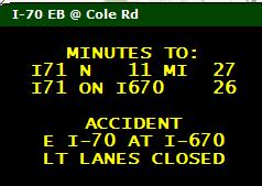
This sign is read the same way as the previous sign shown with only three lines of information. The first panel on the sign above displays for 5 seconds and indicates that the average travel time to stay on I-70 and get to the intersection with I-77 North is currently 27 minutes and that it takes 26 minutes to get to I-71 using I-670. The sign then flips to the second panel and states the reason for the high travel times is that there is an accident on eastbound I-70 at I-670 and that the left lanes are closed.
This is depicted on the map on Buckeye Traffic as shown below:
This can also be shown on multiple DMS in separate physical locations as shown below:
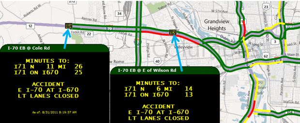 In this case, the traffic going past the sign at Wilson Rd is already experiencing slow traffic but can read what the problem is, while traffic going past the sign at Cole Rd is moving at normal speeds but can read the message to decide if they should take an alternate route.
In some cases, more than 2 travel time destinations may be desired. In this case, it’s possible to have travel times alternating every 5 seconds as well. An example of this is shown below:
This sign is read the same way as the previous sign shown with only three lines of information.
For example, the sign states that it will take 4 minutes to reach E 9th Street using I-90, a 4 mile distance, and 5 minutes to reach E 9th Street using I-490 to I-77north. Also, it will take 9 minutes to reach the I-77/I-480 intersection using I-77, a 9 mile distance, and 8 minutes to reach the I-77/I-480 on SR-176, a 9 mile distance.
Typically, if a sign is alternating between 2 panels of information, the 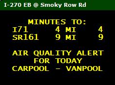 first panel (first three lines) will feature travel times, and the next panel (next three lines) will show information regarding a missing person, road activity, traffic conditions, additional travel times, or other information deemed relevant to motorists.